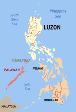
Palawan (pron. /pəˈlɑːwɑːn/), officially the Province of Palawan (CuyononProbinsya i'ang Palawan / ParaguaTagalogLalawigan ng Palawan) is an archipelagic province of the Philippines that is located in the region of MIMAROPA. It is the largest province in the country in terms of total area of jurisdiction. Its capital is the city of Puerto Princesa, but the city is governed independently from the province as a highly urbanized city.
Palawan
Province of Palawan
Palawan Provincial Capitol
Flag of Palawan
Flag
Official seal of Palawan
Seal
Nickname(s): 
  • Philippines' Best Island[3]
  • Philippines' Last Frontier[4][5]
  • The (Spaniards') Land of Promise[6]
Location in the Philippines
Coordinates: 10°00′N 118°50′E
CountryPhilippines
RegionMimaropa (Region IV-B) (in transition[1][2])
Founded1818
CapitalPuerto Princesa
Government
 • TypeSangguniang Panlalawigan
 • GovernorJose C. Alvarez (PDP-LABAN)
 • Vice GovernorVictorino Dennis M. Socrates (NUP)
Area
 • Total14,649.73 km2(5,656.29 sq mi)
Area rank1st out of 81
 (excludes Puerto Princesa)
Highest elevation 2,085 m (6,841 ft)
Population 
(2015 census)[8]
 • Total849,469
 • Rank31st out of 81
 • Density58/km2 (150/sq mi)
 • Density rank79th out of 81
 (excludes Puerto Princesa)
Demonym(s)Palaweño
Divisions
 • Independent cities
 • Component cities0
 • Municipalities
 • Barangays
 • Districts1st to 3rd districts of Palawan (shared withPuerto Princesa City)
Time zoneUTC+8 (PHT)
ZIP Code
5300–5322
IDD:area code+63 (0)48
ISO 3166 codePH
Spoken languages
Websitewww.palawan.gov.ph
The islands of Palawan stretch between Mindoro in the northeast and Borneo in the southwest. It lies between the South China Sea and the Sulu Sea. The province is named after its largest island, Palawan Island(09°30′N 118°30′E), measuring 450 kilometres (280 mi) long, and 50 kilometres (31 mi) wide.[9][10]

Comments

Popular posts from this blog

Mail Merge

Advanced Word Processing Skills: Mail Merge

TARLAC